BIM in Aircraft Design
The aviation industry has evolved rapidly along with the growing demands on operational efficiency, passenger experience, and sustainability. Building Information Modelling (BIM) technology plays an important role in complex and multifunctional airport projects and helps to manage the critical infrastructure of these airports.
BIM technology helps to provide a centralised digital platform, in which the complexity among all disciplines and phases of the airport has been managed.
Discuss the key tools used in the aircraft design process
Autodesk Revit & Civil 3D
Autodesk Revit & Civil 3D have become the industry-leading platforms, which have been used for parametric modelling, detection of clashes and grading design.
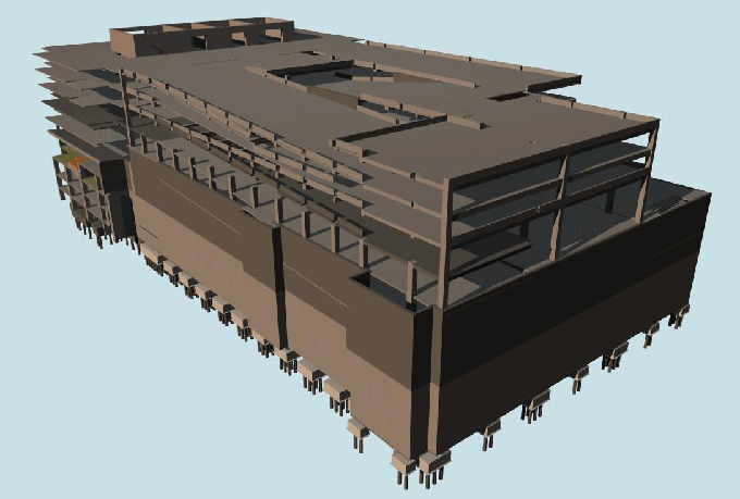
Tekla Structures
This tool has been used for advanced steel and concrete modelling processes, which have been used in India’s Chennai Airport project.
Esri ArcGIS Pro
This BIM tool has been used for geospatial data management and the climate‑scenario mapping process.
Navisworks
This BIM tool helps to provide a comprehensive coordination environment, which involves scheduling simulation process, model aggregation process, and 4D animation process.
Open BIM Standards
Open BIM Standards help to ensure interoperability across the different design tools and stakeholders, which is mandated in many global airport projects.
Bentley OpenBuildings Designer
This BIM tool helps to integrate architectural and structural workflows along with robust analysis tools.
AI‑Powered Plugins
AI‑Powered Plugins help to automate the layout optimisation process and the data-driven decision-making process.
Learn about the BIM fundamentals in revolutionising the Air Military
Evolution of airport designs from 2D to 3D
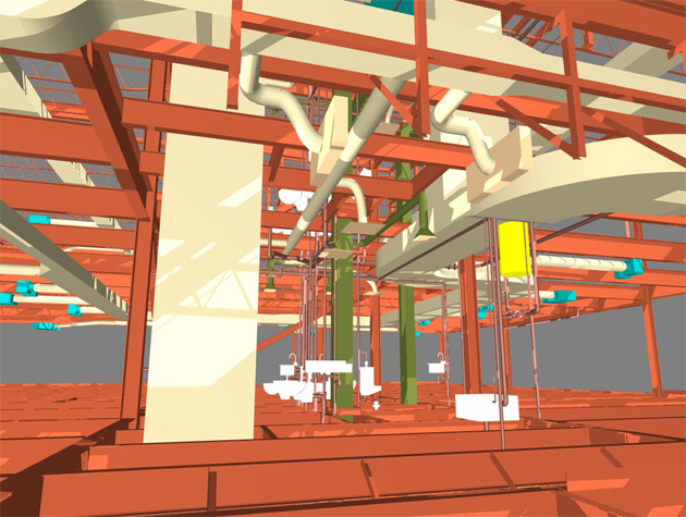
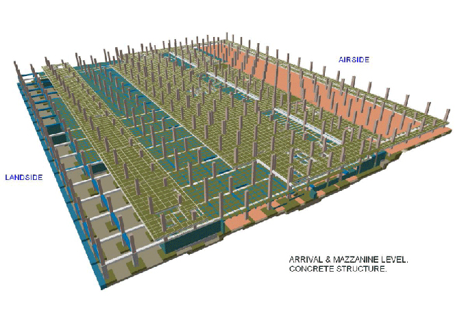
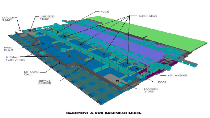
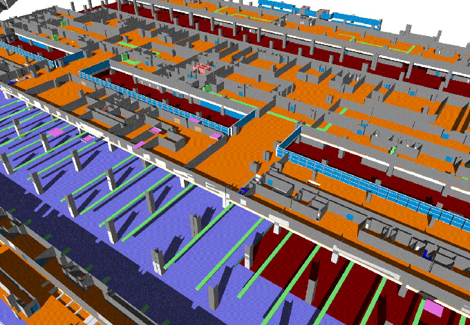
BIM technology helps to replace the conventional 2D plans with a unified 3D design model, which helps to encompass spatial relationships, geometry and rich metadata. With the help of the BIM technology, stakeholders can access a living design model where HVAC ducts, structural frames, electrical conduits and plumbing networks coexist in a single environment. This paradigm shift helps to reduce misinterpretation, design clashes and manual rework for the large-scale airports.
Scheduling and cost analysis feature
BIM technology helps to integrate the scheduling and cost estimation processes, which enable the project team members to link the construction process to generating time‑lapse simulations and model design elements. The cost data achieved by the BIM technology has been attached to the material quantities and labour rates. This helps to enable the tracking of the dynamic budget tracking process and helps to empower decision-makers for phasing or value engineering.
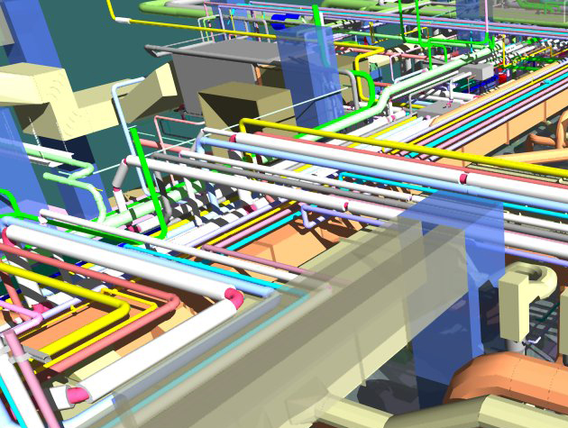
Clash detection and coordination feature
BIM technology involves flagging interferences, such as a duct penetrating a steel beam, which allows the project design team members to resolve conflicts virtually rather than during the construction process, where corrections are more expensive.
Discuss the advanced integration of the BIM technology for smarter aircraft designs
Use of BIM and IoT for proactive maintenance
BIM technology, along with the Internet of Things (IoT) sensors, helps to transform 3D design models into real-time operational hubs. Embedded sensors feed performance data into the BIM environment, helping to enable facility managers to monitor equipment health and schedule preventative maintenance before failures occur.
Use of AI and machine learning for digital automation
Artificial Intelligence and Machine learning have the potential to automate repetitive tasks, for example, generating parametric runway geometry or optimising mechanical layouts, thus helping to accelerate the design cycle, as well as helping to reduce human errors in the design process.
To get online demonstration, watch the following video tutorial.
Video Source: Balkan Architect
In addition, the AI‑driven generative design process helps to propose multiple terminal layouts, which can balance the security checkpoints, passenger flow and retail areas, on the basis of the predefined performance criteria.
Use of GIS for climate change resilience
The integration of the Geographic Information Systems (GIS) along with the BIM technology helps to enrich airport design models, along with hydrology, terrain, and climate‑projection data. GIS for climate change adaptation helps to allow the planners to simulate flooding scenarios, heat islands, and wind patterns, drainage designs, informing resilient runway elevations and material selections. As an example, Pittsburgh International Airport adopts GIS‑BIM digital twins, which helped the airport map flood‑risk zones, as well as help to optimise stormwater infrastructure to mitigate climate threats. In this airport, the GIS application also helps to track fire‑suppression assets, as well as, this application also involves in turf‑maintenance boundaries and pollution‑monitoring stations. Thus, this GIS application helps to improve operational resilience and helps to support climate-change initiatives.
Use of digital twin technology
The digital twin technology is a dynamic and data-rich replica of the physical infrastructure. While the BIM design model has been connected to live data streams, for example, GIS, IoT, and CCTV, it has become a virtual twin, capable of simulating operational scenarios, training emergency responders and forecasting traffic peaks. This feedback loop helps to improve the situational awareness and long‑term asset optimisation process.
Gallery
Feel free to contact us for BIM requirements. One of our representative will respond you within 24 Hours. Send us your projects requirement today and grow your project.
Explore More !